
In 1864, miners were so desperate to find gold that they diverted the Yarra River into a tunnel so they could comb the river bed. The river still flows through the tunnel near Warburton, 90km east of Melbourne.
Subscribe now for unlimited access.
$0/
(min cost $0)
or signup to continue reading
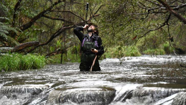
Christian Taylor has already found intriguing nuggets like this, 14km into his unpaid quest to photograph the river's entire 218km accessible length, from a national park near Upper Yarra reservoir to industrial Williamstown.
Mr Taylor likens his project, the Yarra River Photo Survey, to a Google Street View of our famous waterway.
Using a spherical camera the size of a TV remote control, mounted on his backpack, he takes 360 degree images every 10 to 20 metres.
They are being uploaded to be freely available – go to Google Maps and do a search for Reefton, Victoria.
Zoom in on Reefton, then click on the small yellow person at the bottom right of the screen.
By clicking on any of the blue circles denoting an image, you can then scroll around inside the 360 degree photo sphere, and scroll along the river via images at the bottom of the screen.
So far there are more than 600 images, which have been viewed over 220,000 times.
On a river flat near Reefton, he snapped a long abandoned colonial farm hut that's falling down, its paddocks overtaken by scrub.

Abandoned farm on a river flat, now part of the Yarra Ranges National Park at Reefton. Photo: Christian Taylor

A car wreck in the Yarra bank, off Woods Point Road near Warburton. Photo: Christian Taylor
He is walking at present, sometimes chest-deep in water, because the river is fairly shallow; further downstream he will kayak, when he might do 5km a day and have the camera on automatic timer. The entire project could take up to three years.
He always brings another volunteer to help measure water quality, to tell him when the camera is straight, "and generally when I get thigh deep in mud, to pull me out. And also if I break a leg or get bitten by a snake to tell them where the body is".
Mr Taylor, a civil engineer, covers about 1.5km each Sunday he goes out.
Many photos are stunning, but they're meant to be useful, as snapshots of erosion, weeds, feral animals and recreational use for future governments, land owners, campers and historians.

Small rapid in the Yarra Ranges National Park, Reefton. Photo: Christian Taylor
Mr Taylor says it's good fun. "I work in the city, I live in Coburg; I like to get out and see big trees, the river and get away from a busy working and family life."
"And it's great to go on a bushwalk. A project like this gives you a purpose. In a structured way, you work your way down the river.
"You see parts of the river you would not see otherwise. You see some absolutely beautiful spots that a lot of people haven't seen before, that you would never come across day to day."

